Surface Winds
Surface winds result from three factors: pressure gradient force, Coriolis effect, and frictional force. All surface winds begin with the development of a pressure gradient across space. The force generated by the pressure gradient determines the initial speed and direction of the resulting airflow. On a surface weather map, we can determine the relative strength of surface pressure gradients by examining isobar patterns. The closer the spacing between consecutive isobars, the steeper the gradient and the faster the wind will blow. The Coriolis effect influences surface winds by deflecting this air flow off its path. This deflection is to the right in the Northern Hemisphere and to the left in the Southern Hemisphere. Close to Earth's surface, a third force influences the wind: friction. Frictional force acts to decelerate moving air. This force acts in a direction opposite to the pressure gradient force, causing acceleration.
Figure 7.19 graphically models the formation of a surface wind as the combined action of pressure gradient force, Coriolis effect, and frictional force. Each of these factors has a direction relative to the surface wind. As discussed, the pressure gradient force is the wind's initial and primary driving force. Figure 7.19 indicates that the pressure gradient force acts perpendicular to the isobars, generating a flow from high to low atmospheric pressure. The Coriolis effect works on wind as soon as the air begins to move. Note that this influence is directed to the right (Northern Hemisphere) and at right angles to the direction of the surface wind. The frictional force is shown as a force that acts opposite to the direction that surface wind is blowing.
Surface winds tend to cross isobars at angles varying between 10 and 45°. This variation is due to the amount of friction imparted on the moving airflows by the Earth's surface. Lower friction means higher wind speeds and a stronger Coriolis effect. The Coriolis effect controls the amount of deflection acting on the wind. In a nearly frictionless environment (such as the upper atmosphere), the Coriolis effect deflects the wind until it flows perpendicular to the direction of the pressure gradient force (or parallel to the isobars). Near ground level, the strength of the Coriolis effect is reduced because friction decreases wind speed. In turn, this reduction in the Coriolis effect results in less deflection of the surface wind from its path as first defined by the pressure gradient force. Surface winds intersect the isobars over relatively smooth surfaces, such as oceans, at angles between 10 and 20°. Rough terrestrial surfaces can reduce wind speeds by 30 to 50%. The subsequent reduction in Coriolis deflection causes these winds to intersect isobars at angles between 20 and 45°.
Figure 7.20 illustrates the patterns of surface airflow that occur around low and high-pressure centers in the Northern and Southern Hemispheres. In the Northern Hemisphere, low pressure centers (also called cyclones) have an airflow that rotates counterclockwise and inward. Northern Hemisphere high pressure centers (also called anticyclones) have a flow pattern that is outward and clockwise. In the Southern Hemisphere, the Coriolis effect acts to the left rather than the right. This effect causes the winds of the Southern Hemisphere to blow clockwise and inward around surface lows and counterclockwise and outward around surface highs.
Upper Air Winds
Upper air winds are defined as any wind that occurs above 1000 m (3000 ft) from the Earth’s surface. Upper air winds differ from surface winds in one respect: the influence of friction on airflow is minimal. As a result, upper air winds are the product of only two forces: the pressure gradient force and the Coriolis effect. Figure 7.21 describes the forces acting on both upper air and surface winds. This figure shows that the pressure-gradient force and the Coriolis effect act in opposite directions in an upper-air wind. The balance between these two factors also causes an upper air wind to flow parallel to the isobars. Winds in the upper atmosphere flowing in a straight path are commonly calledgeostrophic winds.
Gradient Winds
Winds above the Earth's surface do not always travel in straight lines. Upper air winds sometimes flow around the curved isobars of high (anticyclone) or low (cyclone) pressure centers. Winds that blow around curved isobars above the level of friction are known asgradient winds. Figure 7.22 describes the flow patterns of gradient winds around high and low-pressure centers for both the Northern and Southern Hemispheres. Note the difference in the flow direction between the hemispheres.
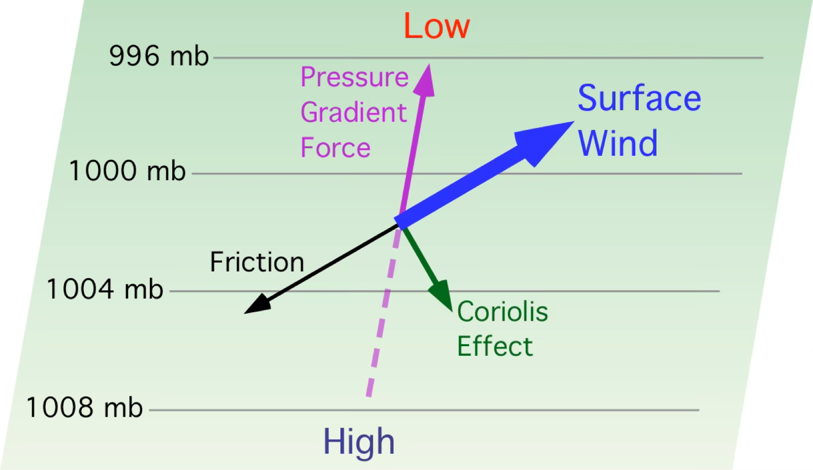
FIGURE 7.19 Winds near the Earth’s surface are influenced by the pressure gradient force, the Coriolis effect, and surface friction. Image Copyright: Michael Pidwirny.
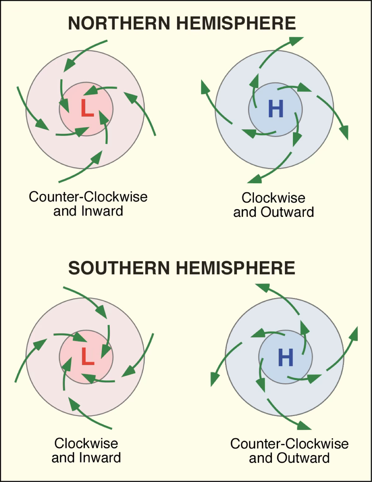
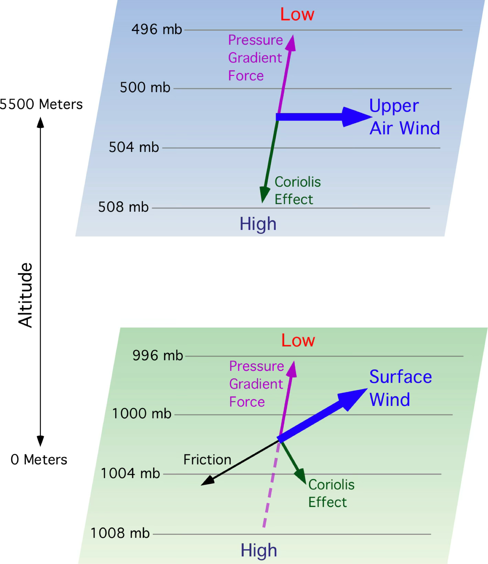

FIGURE 7.21 Comparison of forces acting on winds near the Earth’s surface and in the upper atmosphere. In the upper atmosphere, frictional effects are negligible, resulting in a balance between the pressure gradient force and the Coriolis effect. This balance causes upper air winds to flow parallel to the isobars. Image Copyright: Michael Pidwirny.
FIGURE 7.20 Surface wind patterns associated with high and low pressure systems in the Northern and Southern Hemispheres. Image Copyright: Michael Pidwirny.
FIGURE 7.22 Upper atmosphere wind patterns associated with high and low pressure systems in the Northern and Southern Hemispheres. Image Copyright: Michael Pidwirny.